
GIS
GIS: Turning Location Data Into Decisions
Geography, and geospatial data, underpins almost every decision an organisation makes: where assets are, how they relate to one another, what risks they are exposed to, and how efficiently they can be managed. Geographic Information Systems (GIS) is the discipline that makes those relationships visible, measurable, and actionable.
At Latitude Geospatial, our award-winning GIS team consists of Chartered Geographers with over a combined total of 80 years of experience across the public and private sectors, from local authorities and environmental agencies to global mining operators and infrastructure companies. We provide a full range of services, from initial data capture and database design through to analysis, web application development, and enterprise system deployments.
Whatever stage your organisation is at with its GIS capabilities, we can help.
-
GIS is a framework for capturing, storing, managing, analysing, and presenting data that has a geospatial component. In practical terms, this means any data that can be associated with a location – from infrastructure assets, population statistics, environmental measurements, and transport networks.
The power of GIS lies in its ability to reveal relationships and patterns between datasets that would otherwise be invisible in a spreadsheet or a standard database. By understanding not just what the data says but where it applies, organisations can make better-informed decisions across planning, operations, risk management, and resource allocation.
GIS is not a single product or platform; it is an approach to working with spatial data that spans desktop software, cloud-hosted platforms, web applications, enterprise databases, and field collection tools. Our team is experienced across all of these environments.
GIS Application Development & WebGIS
For many organisations, the most effective way to deploy GIS is through a web-based application that puts spatial data and analysis tools in the hands of the people who need them – reducing the requirements for specialist GIS software on every device.
We design and build bespoke web mapping applications and interactive dashboards tailored to the specific requirements of each client. These range from simple, field-facing data collection tools to complex, multi-layered analytical platforms accessible by multiple teams across and organisation.
Our webGIS development works include:
Bespoke web mapping applications using Esri ArcGIS Online, Experience Builder, and related platforms
Custom dashboard design for operational reporting, asset management, and programme monitoring
Field data collection applications such as Survey123, Field Maps, and similar tools
Interactive public-facing maps for planning consultations and stakeholder engagement
Integration of live data feeds and IoT sensor outputs into web-hosted mapping environments
Enterprise GIS & Database Management
For organisations with significant volumes of spatial data, or those whose operations depend on spatial data being available readily across multiple teams and systems, a properly designed enterprise GIS environment is essential.
We design and implement enterprise geodatabase solutions built on platforms including Esri ArcGIS Enterprise, PostgreSQL with PostGIS, and Microsoft SQL Server with spatial extensions. Our work in this area includes:
Enterprise Geodatabase Design & Build: Structured, scalable spatial databases designed around your organisation’s data model and workflow requirements
Spatial Database Migration: Moving legacy data from flat files, CAD systems, or older database formats into a structured, queryable geodatabase environment
Multi-User Editing Environment: Configuring versioned geodatabases that allow multiple teams to edit and manage data concurrently without data integrity issues
Geodatabase Administration: Ongoing management, performance optimisation, and user access control for live enterprise GIS environments
Topology & Data Quality Rule Implementation: Establishing the rules that ensure spatial data remains accurate, consistent, and fit for purpose as it is updated over time

ETL – Data Integration & Transformation
Most organisations hold spatial data in a variety of formats and systems that do not naturally talk to each other. CAD drawings, spreadsheets, legacy databases, third-party data feeds, and survey outputs all need to be brought together into a consistent, usable form before meaningful analysis can take place.
Our ETL (Extract, Transform, Load) service covers the full process of taking data from its source, cleaning and restructuring it into the required format, and loading it into its destination system. Common ETL tasks we carry out include:
CAD to GIS conversion (DWG/DXF to shapefield, geodatabase, or GeoJSON)
Raster to vector conversion, or vice versa
Point cloud to raster surface
Excel and tabular data geocoding and conversion to spatial formats
Integrating of third-party datasets into client GIS environments
Automated data pipelines for recurring data feeds and scheduled imports
Schema mapping and data harmonisation across disparate source systems
We also advise clients on how to improve their upstream data collection processes to reduce the volume of transformation work required at the point of analysis – saving time and reducing the risk of errors accumulating across the workflow.
Spatial Analysis & Location Intelligence
The primary purpose of GIS is to support better decisions, and that requires rigorous analysis of spatial data rather than simply mapping what already exists.
Our award-winning analytical services draw on a broad range of geoprocessing and statistical methods to answer specific questions about location, distribution, risk, accessibility, and change over time. Examples of analytical workflows we carry out include:
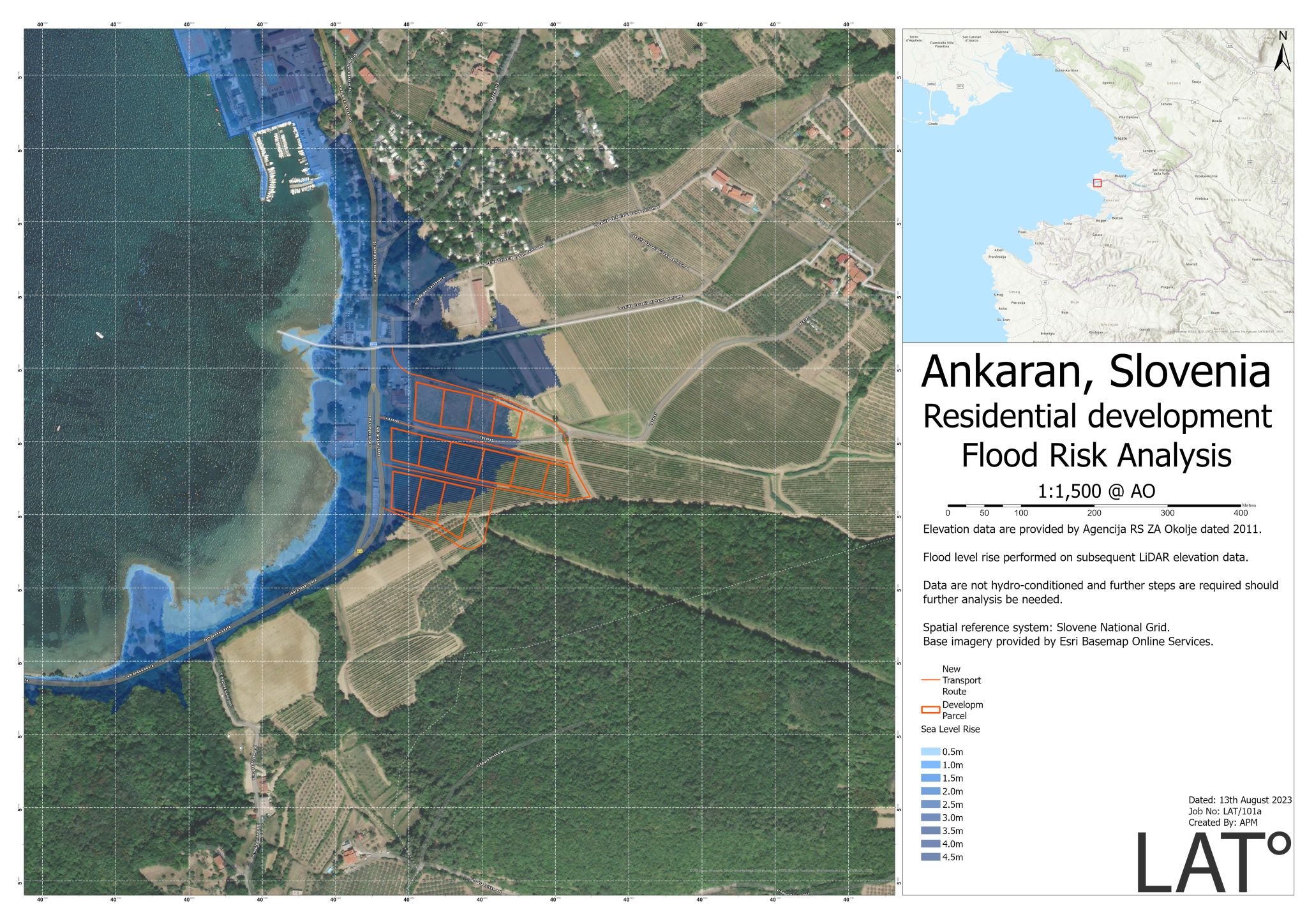
Flood Risk & Inundation Modelling: Identifying areas at risk of surface water, fluvial, or coastal flooding and assessing the implications for development, infrastructure, and insurance
Catchment & Accessibility Analysis: Understanding how populations relate to services, facilities, or infrastructure, including drive-time and walk-time modelling
Site Suitability Assessments: Evaluating candidate locations for new development, infrastructure, or operational facilities against multiple spatial criteria simultaneously
Crime & Incident Pattern Analysis: Identifying hotspots and trends in incident data to support resource allocation and prevention planning
Socio-Economic & Deprivation Analysis: Mapping patterns of need and access across geographic areas to support policy, service delivery, and funding applications
Land Use & Land Classification Analysis: Classifying and monitoring how land is being used and changes over time, drawing upon drone, fixed-wing, and satellite imagery
Dead Ground & Line-of-Sight Analysis: Used extensively in telecommunications, security, and defence applications to understand what is and is not visible from a given location
Spatio-Temporal Analysis: Analysing how spatial patterns change over time, incorporating timestamps into datasets to identify trends and anomalies
-
We are platform-agnostic in our approach and work across a wide range of GIS environments. Our team has experience with:
Esri ArcGIS: Including ArcGIS Pro, ArcGIS Online, ArcGIS Enterprise, Experience Builder, Survey123, Field Maps, and Insights.
QGIS: Open-source desktop GIS workflows
PostGIS/PostgreSQL: Open-source enterprise spatial database environments
Python: Including ArcPy and GeoPandas for scripted automated geoprocessing
JavaScript & Web-Mapping Libraries: Including Leaflet and ArcGIS Maps SDK for JavaScript, for custom web application development

Situational Awareness Products
For clients in sectors where understanding the current state of an area or operation at a given point in time is critical, including construction, security & defence, emergency management, and mining, we produce structured situational awareness products that present complex spatial data in a clear, accessible format.
These products allow decision-makers to understand where assets are, what condition they are in, how infrastructure has been affected by an event, and where attention needs to be directed without needing to interpret raw data themselves.
Our situational awareness work has supported projects in security and intelligence, aviation, construction programme monitoring, and post-event damage assessments.
3D Visualisations & Flythroughs
Where projects or sites needs to be communicated to stakeholders who are not able to visit in person, or where a 3D understanding of the environment is essential to decision-making, we produce high-quality 3D models, rendered scenes, and animated flythroughs.
These products are generated from a combination of drone survey data, LiDAR point clouds, satellite-based imagery, and GIS datasets, and are increasingly used in planning consultations, stakeholder presentations, situational awareness briefs, and public engagement processes.
Cartography & Map Production
Well-designed maps remain one of the most effective ways to communicate spatial information to a wide audience. Our cartography service covers the production of bespoke maps and charts for a broad range of purposes, including:
Technical maps for planning applications and environmental reports
Operational maps for field teams and site personnel
Presentation-quality maps for stakeholder briefings and public consultation
Printed and digital map products at a range of scales
All cartographic work is produced by experienced GIS professionals with a thorough understanding of cartographic principles, data accuracy, and visual communication.
GIS is only as valuable as the people who implement and manage it. With 80 years combined experience, Chartered Geographers status, and a track record across sectors ranging from construction and mining to transport and security, our team is well placed to support your organisation’s spatial data needs.
Whether you need a one-off analytical product, a bespoke web application, or a fully managed enterprise GIS environment, we would be pleased to discuss your requirements.
Trusted partners:


Testimonials
Get in touch
-
GIS understands how objects “interact” with other objects through space and time. "Everything is related to everything else, but near things are more related than distant things", Tobler’s First Law of Geography.
-
Modern GIS accept most spatial data file formats including, but not limited to, shapefiles, geojson, geotiff, postGIS, and more.
-
GIS begins with data capture such as a drone survey. Data storage and management within geodatabases are the next steps. Commonly followed by analysis utilising spatial analysis tools. Visualisation is a key step within the workflow. Generating cartographic products so that stakeholders at all levels can understand spatial data.
-
Topology is a set of rules that ensures your spatial data product is accurate. For example, a rule might state that “property boundaries must not overlap”. Without topology rules, the spatial dataset might manage a database with incorrect boundary information.
-
Yes. GIS can handle the 4th dimension of time; known as 4D GIS. By adding timestamps to spatial datasets, spatio-temporal analysis can be carried out and patterns can be realised.