
Remote Sensing
Remote Sensing: A Clearer Picture
Some of the most valuable information about a location cannot be collected on foot. Whether you need to monitor a vast area of land on a recurring basis, assess the condition of vegetation across a region, track ground deformation at a remote site, or respond rapidly to a natural disaster, satellite and airborne remote sensing gives you access to data that no ground survey team could realistically acquire alone.
At Latitude Geospatial, our remote sensing team works with a broad range of satellite and aerial data sources to deliver analysis and intelligence that supports decision-making across industries as varied as agriculture, environmental management, geology and mining, urban planning, disaster response, and security & defence. As a registered partner of Up42’s, an Airbus subsidiary, this gives our clients direct access to some of the highest resolution commercial satellite imagery available on the market – also with the ability to task satellites for repeat visits over a specific area of interest.
What Is Remote Sensing?
Remote Sensing is the process of collecting information about the Earth’s surface, or objects on it, without ever making physical contact with them. This is achieved by measuring the energy that object reflects or emits across different parts of the electromagnetic spectrum, and interpreting those measurements to understand the properties and condition of what is being observed.
In practice, this means acquiring data from sensors mounted on satellites, aircraft, drones, or hand-held platforms, and processing that data to produce imagery, maps, 3D environments, and analytical products that reveal things which would be difficult, time-consuming, or impossible to measure from the ground.
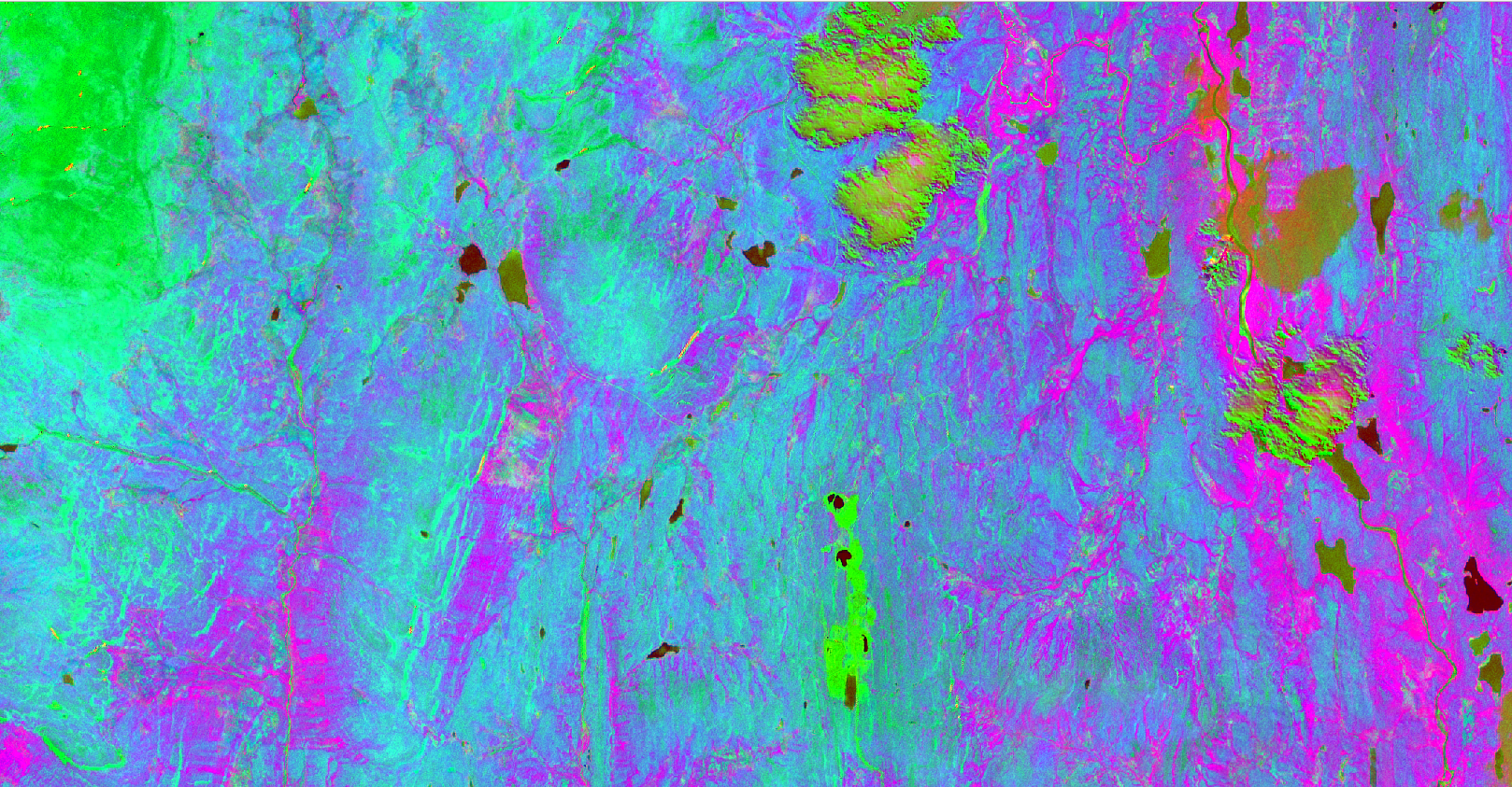
Remote sensing sensors fall into two broad categories. Passive sensors measure naturally occurring energy, primarily from sunlight reflected from the Earth’s surface or object, and can include optical cameras, multispectral sensors, and hyperspectral sensors. Active sensors generate their own energy, emit it towards the target, and measure what is returned. LiDAR and Synthetic Aperture Radar (SAR) are most common examples of active remote sensing platforms. Each has particular strengths, and the most appropriate sensor type depends on what needs to be measured and under what conditions.
Data Sources & Sensor Types
Our remote sensing work draws on a range of satellite, airborne, and hand-held platforms. Understand the difference between them is important when selecting the right approach for a given application.

Optical & Multispectral Imagery
Optical satellite, airborne, and hand-held imagery captures the Earth’s surface in visible and near-infrared wavelengths, producing imagery that is visually intuitive and wide used across most sectors. Multispectral sensors extend beyond the visible spectrum, capturing data in discrete bands, such as near-infrared (NIR), red-edge, and shortwave-infrared (SWIR), that reveal information about vegetation health, soil moisture, land cover, and surface mineralogy that is not visible to the naked eye.
Through our partnership with Up42, we have access to very high-resolution optical imagery from platforms including Pleiades, Pleiades Neo, SPOT, and other commercial satellites. This imagery can be provided as single acquisitions from their archive or through tasked collection over a client-specific area and time window.
Hyperspectral Imagery
Where multispectral sensors capture data in a small number of broad spectral bands, hyperspectral sensors capture data across hundreds of narrow, contiguous bands across the electromagnetic spectrum. This produces a detailed spectral signature for every pixel in the imagery, allowing materials, minerals, vegetation species, and surface conditions to be identified and classified with a level of precision that multispectral cannot match.
Hyperspectral data is particularly valuable in geology and mineral exploration, precision agriculture, water quality monitoring, and defence & intelligence applications.
Synthetic Aperture Radar (SAR)
SAR sensors emit microwave energy and measure the return signal from Earth’s surface. Because SAR operates independently of sunlight and can penetrate cloud cover, it is one of the few remote sensing platforms capable of acquiring useful data under almost any weather conditions and at any time of day or night. This makes it particularly valuable in regions with persistent cloud cover, in disaster response scenarios, and for applications where frequent, reliable data acquisition is essential.
SAR data is widely used for ground deformation monitoring (including subsidence and landslide detection), flood extent mapping, sea ice monitoring, ship detection, and forest biomass estimation.
LiDAR
Light Detection and Ranging (LiDAR) uses laser pulses to measure distance to objects and surfaces with very high precision. Airborne LiDAR, mounted on fixed-wing, rotary-wing, or drones, produces dense 3D point clouds that can be used to also generate accurate Digital Elevation Models (DEMs) such as Digital Terrain Models (DTMs) and Digital Surface Models (DSMs), and detailed structural models of vegetation and built features.
Spaceborne LiDAR platforms extend this capability to a global scale and provide elevation measurements and vegetation canopy data across areas that would be impractical to cover with airborne sensors alone.
LiDAR is used extensively in forestry, flood modelling, topographic surveys, infrastructure corridor surveys, archaeological feature detection, and coastal monitoring.
Drone-Mounted Sensors
For applications that require a very high spatial resolution over smaller areas, drone-mounted sensors offer a flexible and cost-effective alternative to satellite or manned airborne platforms. Our drone survey team can deploy multispectral, thermal infrared, LiDAR, and optical sensors on drones, producing datasets that integrate directly with the analysis workflows described throughout our service pages.
Applications By Sector
Remote sensing has practical applications across a broad range of industries.
Environmental Monitoring & Conservation: Tracking deforestation, wetland loss, coastal erosion, glacial retreat, and other indicators of an environmental change. Assessing the health of protected habitats and identifying encroachment or degradation over time.
Agriculture & Forestry: Mapping crop health and identifying stress at field scale. Estimating biomass and timber volumes. Monitoring soil moisture and identifying drainage issues. Supporting precision agriculture interventions and sustainable forest management.
Geology & Mining: Mapping surface geology and identifying mineralogical targets for exploration. Monitoring ground deformation above active mining sites. Assessing the extents of tailings and waste rock deposits from above.
Urban Planning & Development: Analysing land use patterns, monitoring urban growth, and assessing the heat island effect through land surface temperature mapping. Supporting infrastructure planning with up-to-date and near real-time high-resolution imagery.
Disaster Management & Emergency Response: Rapid damage assessment following floods, earthquakes, wildfires, and storms. Monitoring the progression of active events and supporting logistical efforts of relief operations.
Security & Intelligence: Change detection over areas of interest. Infrastructure monitoring. Object identification and classification. Our team has experience working to the specific data handling and product standards required in this industry.
Coastal & Marine: Mapping coastal changes and erosion, monitoring seagrass and coral reef health, tracking shipping and vessel activity, and assessing the condition of coastal infrastructure.
With access to some of the most capable satellite platforms available on the market, and a team experienced in both data acquisition and rigorous analytical processes, Latitude Geospatial is well placed to support remote sensing projects of any scale.
Whether you are monitoring a single site, tracking changes across a region, or need rapid data acquisition in response to an event, we would be pleased to discuss your requirements.
Trusted partners:


Testimonials
Get in touch
-
Remote sensing is the process of detecting and monitoring the physical characteristics of an area or object by measuring its reflected and emitted radiation.
Synthetic Aperture Radar (SAR), hyperspectral, multispectral, optical RGB), LiDAR are all example of remote sensing platforms.
-
Passive sensors measure natural energy, such as sunlight, reflected from the Earth’s surface.
Active sensors emit their own energy source and measure the reflectance, such as LiDAR.
-
Light Detection and Ranging (LiDAR) uses lasers (light) to map the distance to objects. It is used to create highly accurate 3D models of features such, forests, buildings, and coastlines.
-
LiDAR sensors, or platforms, can be mounted to fixed-wing aircraft such as planes, helicopters, UAS/drones, and even mounted to mobile-mapping platforms such as hand-held SLAM scanners.
-
Photogrammetry is the science of “stitching” overlapping 2D images together to generate 3D models or 2D orthomosaic imagery.