Coastal Monitoring & Flood Defence
Globally, sea-level rise is projected to threaten 95% of coastal regions during the 21st century. Coastal zones represent some of the most dynamic and environmentally sensitive regions across the world. Challenges such as shoreline erosion, rising sea levels, increasing infrastructure demands, and habitat degradation necessitate a robust and informed approach to management. Effective coastal stewardship therefore depends on the availability of accurate, current, and multi-source spatial data. LAT addresses this need by delivering integrated geospatial services that transform complex environmental datasets into actionable, decision-support insights.
Remote Sensing & GIS
At the core of coastal management is understanding what is changing, where, and how fast. LAT’s GIS and remote sensing services combine satellite, UAVS and LiDAR data into decision-ready mapping systems.
How does this help coastal management:
Shoreline change detection (erosion & accretion tracking)
Habitat monitoring (wetlands, inter-tidal zones, coral systems)
Flood risk mapping and climate resilience planning
Data integration for policy and planning
Latitude Geospatial delivers sub-3 cm accuracy mapping, which is critical when small elevation changes can mean major flood risks.
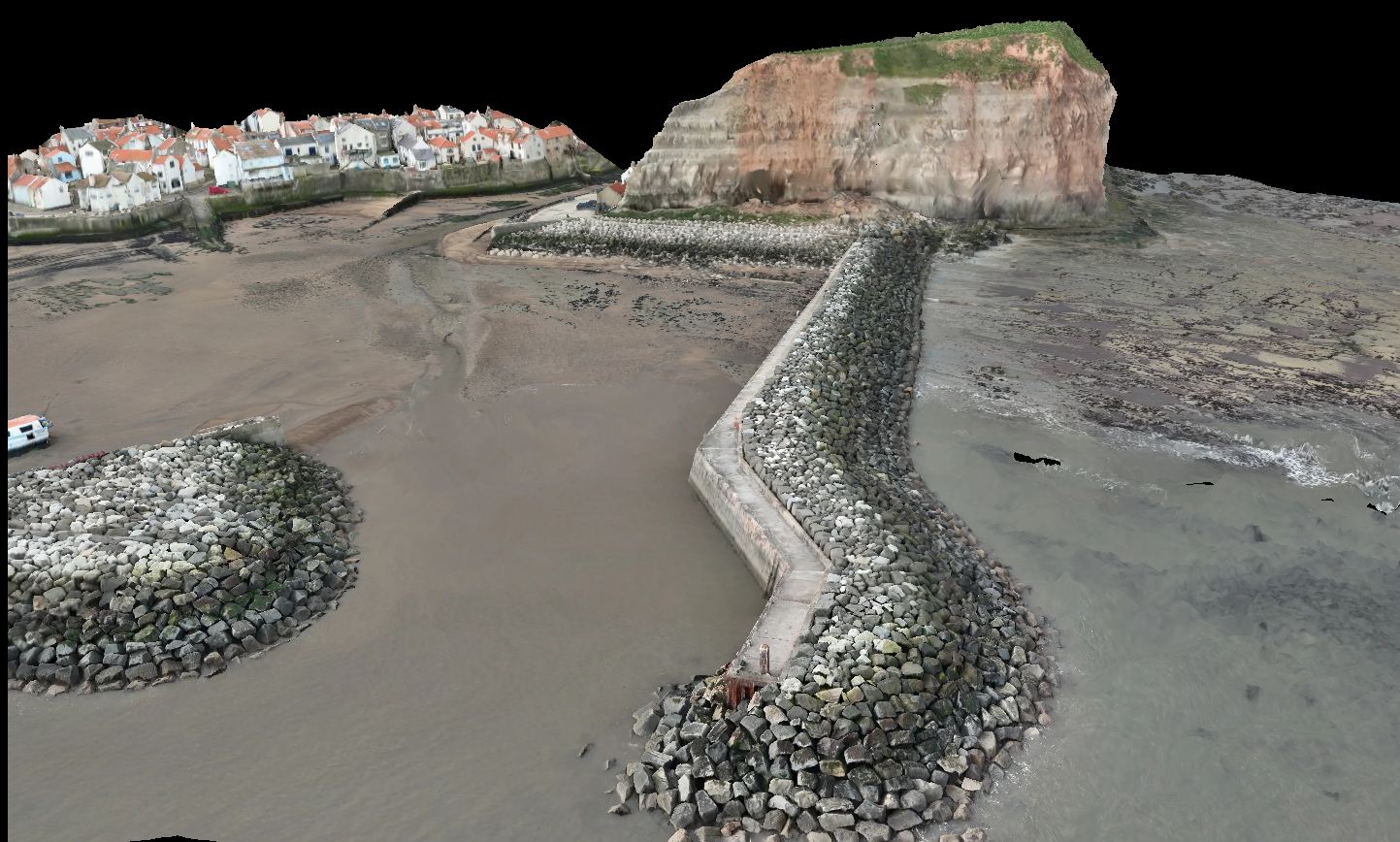
Drone Surveys
Traditional surveys are slow and often unsafe in coastal environments. LAT’s UAS (drone) surveys solve this by capturing high-resolution aerial data quickly and safely.
Coastal Applications:
Mapping erosion hotspots and cliff instability
Monitoring coastal infrastructure (ports, breakwaters, seawalls, pipelines)
Creating 3D terrain models of beaches, dunes, and infrastructure
Rapid post-storm damage assessment
This is critical as UAS surveys reduce field risk and deliver fast, regulator ready datasets, which is crucial after extreme weather events.
Coastal planning depends on having a reliable baseline of land elevation and features.
LAT’s land and topographic surveys provide:
Topographic mapping
Dense point clouds
Elevation models (DEMs)
Boundary and cadastral data
Coastal impact:
Identifying flood-prone zones
Supporting coastal development planning
Designing defensive infrastructure (breakwaters, barriers)
Without accurate baseline data, coastal projects risk delays, cost overruns, and compliance issues.
Integrated Data Platforms: Smarter Coastal Decisions:
LAT goes beyond data collection, we turn it into actionable intelligence through platforms ArcGIS Online.
These systems:
Enable drone data visualisation
Create digital twins of coastal environments
Enable real-time monitoring and reporting
Coastal management benefits:
Track shoreline movement over time
Monitor infrastructure condition
Generate audit-ready reports for regulators
LAT extends its capabilities beyond data acquisition by transforming geospatial information into actionable intelligence through integrated platforms such as ArcGIS Online. By integrating drone data, enabling advanced visualisation, and creating digital representations of coastal environments, these systems support real-time monitoring and informed decision-making. This capability allows coastal managers to track shoreline change, assess infrastructure condition, and generate compliant, audit-ready reports, thereby facilitating a shift from reactive management approaches to more predictive and proactive strategies.
Site Engineering & Project Management
Collecting data is only half the job — coastal projects need execution.
LAT supports:
Infrastructure planning & monitoring
Detailed site works and setting out
3D model generation for necessary dredging activities
Compliance reporting
Multi-agency project coordination
Coastal use cases:
Port and harbour development
Coastal defence construction
Climate adaptation programmes
Latitude Geospatial’s integrated approach ensures that geospatial data is seamlessly translated into engineering workflows, allowing insights derived from surveys and spatial analysis to directly inform the planning, design, and implementation of coastal infrastructure.
Effective coastal management is no longer possible without high-quality geospatial data. By combining drone surveys, GIS, remote sensing, and engineering expertise, we enables a smarter, faster, and more resilient approach to managing our coastlines, turning data into decisions that protect both infrastructure and ecosystems.
Needing to know more? Our team are always ready to help and assist you and your projects. Get in touch for more details.